Below are directions to non-urban locations we may meet with prospective and current Barrett Weimaraner owners. Please call/text Kim with any questions.
Sporting Dogs B&B in Lancaster, CA – Worrell Residence
- Lancaster, CA
- Cellular signal: Good
- Google Map
- Notes: While a high clearance vehicle is not required, please note that neighborhood roads are dirt and/or gravel.
- Directions: The house is NOT on 280th Street and many of the roads do not go through. Use these directions, NOT a GPS! (If you want to find the house on Google Earth, it is one block east of where they position the address.) While a high clearance vehicle is not required, please note that neighborhood roads are dirt and/or gravel.
- From the north of LA: Go North on I-5, about 25 minutes past Magic Mountain. From I-5, exit onto CA-138. Go East about 7 miles (the only direction 138 goes). Turn Left on 300th St. West. This road is clearly marked and is paved. In 1.4 miles, stay straight at the yield sign, Do not go left on the paved road. Cross the aqueduct, go up the slight hill and Turn Right immediately after the dead peach orchard (surrounded by pines). This is Avenue A, though there is no sign. Go 2.25 miles and Turn Right in front of the Midnight Blue House. We are 4/10 mile on the Left. We are fenced and surrounded by trees and you will not see the house until you are at the driveway.
- From Bakersfield / Frazier Park: Go South on I-5 one exit past the Gorman exit and exit onto CA-138. Go East about 7 miles (the only direction 138 goes). Turn Left on 300th St. West. This road is clearly marked and is paved. In 1.4 miles, stay straight at the yield sign, Do not go left on the paved road. Cross the aqueduct, go up the slight hill and Turn Right immediately after the peach orchard (surrounded by pines). This is Avenue A, though there is no sign. Go 2.25 miles and Turn Right in front of the Midnight Blue House. We are 4/10 mile on the Left. We are fenced and surrounded by trees and you will not see the house until you are at the driveway.
- From Lancaster / 3 Points: Go West on CA-138 / Avenue D to 280th St W. Turn Right (north) and drive for 1 ¾ miles. Continue straight through the deep drainage ditch. Take the next road to the right, followed by the next left. We are ¼ mile on the right. We are fenced and surrounded by trees and you will not see the house until you are at the driveway.

Field Trial Locations
- California City – Camp H
- Cellular signal: Good
- GPS Coordinates: 35°11’30.3″N 117°42’35.5″W
- Google Map
- Notes: While a high clearance vehicle is not required, please note that neighborhood roads are dirt and/or gravel.
- Directions:
- From Mojave –
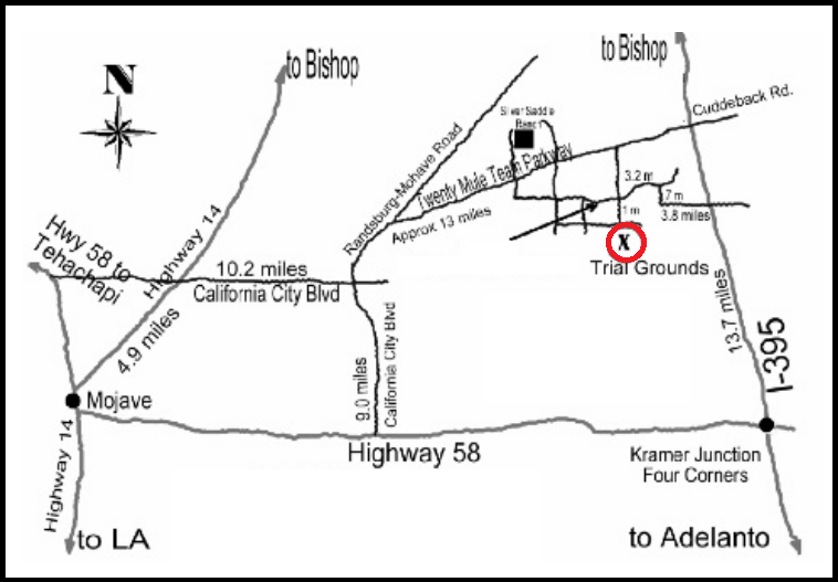
- Go NORTH on Highway 14 to California City. Turn RIGHT onto California City Blvd. and continue 10.3 miles east through town.
- Turn LEFT at Randsburg Mojave Road, which turns into Twenty Mule Team Parkway, and go 11.1 miles towards the Silver Saddle Ranch. When the pavement ends, stay RIGHT and continue on the dirt road for another 3.4 miles.
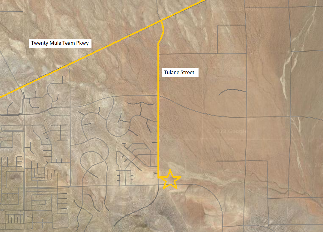
- Turn RIGHT onto Tulane Street, and continue SOUTH for about 2 miles. Camp will be on your left. You will see a multitude of trucks and trailers. Look for a large horse trailer with a sunset mural on the side of it. There may be one or two gray pickup trucks parked next to it. That’s us!
- From Best Western Hotel in California City –
- Turn RIGHT onto California City Blvd. from the hotel. Turn LEFT at Randsburg Mojave Road, which turns into Twenty Mule Team Parkway, and go 11.1 miles towards the Silver Saddle Ranch. When the pavement ends, stay RIGHT and continue on the dirt road for another 3.4 miles.
- Turn RIGHT onto Tulane Street, and continue SOUTH for about 2 miles. Camp will be on your left. You will see a multitude of trucks and trailers. Look for a large horse trailer with a sunset mural on the side of it. There may be one or two gray pickup trucks parked next to it. That’s us!
- From Kramer Junction (Four Corners Area) at intersection of Highway 58 and I-395 –
- Continue NORTH on I-395 for 18.7 miles.
- Turn LEFT at Cuddleback Road/Twenty Mule Team Parkway (this is the same road). Continue WEST for 6 miles.
- Turn LEFT onto Tulane Street, and continue SOUTH for about 2 miles. Camp will be on your left. You will see a multitude of trucks and trailers. Look for a large horse trailer with a sunset mural on the side of it. There may be one or two gray pickup trucks parked next to it. That’s us!
- From Mojave –


Camp H Field Trial Location

Camp H Field Trial Location
- California City – Clay Mine Road
- Cellular signal: Good
- GPS Coordinates: 35°05’50.8″N 117°45’36.2″W
- Google Map
- Notes: While a high clearance vehicle is not required, please note that neighborhood roads are dirt and/or gravel.
- Directions:
- From East or West on Highway 58, Exit 188 at Clay Mine Road, Edwards, CA and head NORTH for 7.1 miles
- At the end of the pavement, turn right on Sequoia Blvd and head EAST for 2.5 miles. The road is unpaved and depending on the weather, may fork a few times to avoid mudholes and water. Keep heading east.

Clay Mine Road Field Trial Location
- Las Cienegas National Conservation Area, Airstrip Group Site, Highway 83, Mile Post 39.7, Sonoita, AZ 85637
- Cellular signal: Good
- GPS Coordinates: 31°47’22.1″N 110°37’57.0″W
- Google Map
- Notes: While a high clearance vehicle is not required, please note that neighborhood roads are dirt and/or gravel.
- Directions:
- From Tucson, Take I-10 East to Sonoita Exit 281
- Travel South on Hwy 83 to Mile Post 40 (Just past Border Patrol
checkpoint) - Turn EAST/LEFT into Las Cienegas NCA, then follow the road to the STOP sign
- Turn LEFT at the STOP sign and proceed to the airstrip

Leave a Reply